GIS SOLUTIONS:

MUNICIPAL OFFICE SUITE
- Tax Parcel Management System
- Permit Tracking System
- Development Tracking System
- Service Request Tracking System
- Road Asset Management System
- Water Asset Management System
- Sewer Asset Management System
- Water Well Management
- Access to Municipal DataWorks
- Mobile Solutions
- User Security Administration

OTHER SOLUTIONS
- Shortest Path Suite
- 911 Emergency Response
- Automated Vehicle Location
- Gas Infrastructure
- Electrical Infrastructure
- Wastewater Flow Demand
- Facility Management
- Municipal Drains
- Forestry

ADD-ONS
- Utility Shutoff/Outage
- EPANET INP Support Module

Guest Book


Project Websites


Other Solutions

Shortest Path

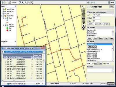
The Hunter GIS Shortest Path Solution permits a web-based method of determining the minimum traveled path along a network (roads) between start and end locations (e.g. the shortest distance between two points). The solution can also determine the optimum route for traversal through a set of points in order, one-to-many, many-to-one, many-to-many and the Travelling Salesman. We can customize the Shortest path solution to your data and business requirements.

Please see our BROCHURE for more information.

Shortest Path