GIS SOLUTIONS:

MUNICIPAL OFFICE SUITE
- Tax Parcel Management System
- Permit Tracking System
- Development Tracking System
- Service Request Tracking System
- Road Asset Management System
- Water Asset Management System
- Sewer Asset Management System
- Water Well Management
- Access to Municipal DataWorks
- Mobile Solutions
- User Security Administration

OTHER SOLUTIONS
- Shortest Path Suite
- 911 Emergency Response
- Automated Vehicle Location
- Gas Infrastructure
- Electrical Infrastructure
- Wastewater Flow Demand
- Facility Management
- Municipal Drains
- Forestry

ADD-ONS
- Utility Shutoff/Outage
- EPANET INP Support Module

Guest Book


Project Websites


Other Solutions

Automated Vehicle Location

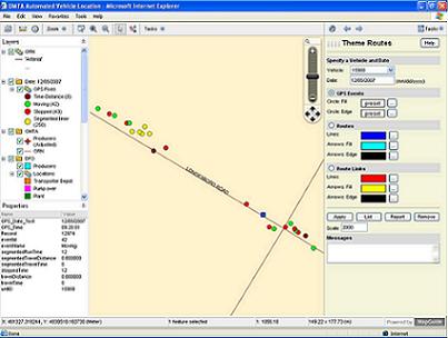
Hunter GIS works with Automated Vehicle Location (AVL) techniques to provide efficient vehicle tracking, function, safety, route optimization and transport rate support solutions. The AVL solution provided by Hunter (HGIS) merges GPS data into a single server database. Utilizing locations themed for a specific date and vehicle identification number, an operator is able to interactively select points along a route representing origin and destination functions. Saved route information can be reported in order to assess the efficiency of the delivery system and apply transport rate formula.

Please see our BROCHURE for more information.

Automated Vehicle Location