GIS SOLUTIONS:

MUNICIPAL OFFICE SUITE
- Tax Parcel Management System
- Permit Tracking System
- Development Tracking System
- Service Request Tracking System
- Mobile Solutions
- Road Asset Management System
- Water Asset Management System
- Sewer Asset Management System
- Access to Municipal DataWorks
- User Security Administration

OTHER SOLUTIONS
- Shortest Path Suite
- 911 Emergency Response
- Automated Vehicle Location
- Gas Infrastructure
- Electrical Infrastructure
- Wastewater Flow Demand
- Facility Management
- Municipal Drains
- Forestry
- Water Well Management

ADD-ONS
- Interactive Map Clipping
- Redline Editor
- Utility Shutoff/Outage
- EPANET INP Support Module

Guest Book


Project Websites


ADD-ONS

Interactive Map Clipping

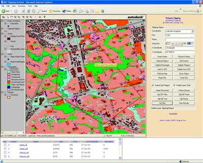
The Hunter GIS Interactive MapClipping allows authorized users over the Internet to interactively clip out portions of a map and the associated database attributes and download files to their desktops. This technology easily adapts itself to ecommerce solutions for revenue recovery.

Please see our BROCHURE for additional information.

Map Clipping